I give two tests during my region unit. One is the map test. The other is a regions project. Each student makes a brochure over two regions. You can download my project checklist below.
I give the students a few days to finish the brochure in class. I do allow students to take the work home on the last day before it is due. However, I like for them to complete it in class.
I do not give a lot of directions other than the checklist. I am not a fan of rubrics, as I find them too vague. You either have what’s on the checklist in your brochure, or you do not. The only vague statement asks for “quality, neat work.” I don’t feel bad about being vague about that one since it is only worth ten points.
Some years I have a lot of Texas Highways magazines around. When I do, I allow students to cut things out to help with their illustrations. If not, I simply ask students to do their best with drawing.
I give the students regular, white copy paper to fold for their brochure. This project covers a lot of TEKS and reinforces their learning.
On the day the brochures are due, I have a museum walk to share their work. We simply lay out the brochures on desks all around the room. I turn on some soft music and allow them to look around quietly. They love showing off their work to their peers, and I think it is good for them to get one last look at the regions in a different light.
TEKS:
identify, locate, and describe the physical regions of Texas (Mountains and Basins, Great Plains, North Central Plains, Coastal Plains), including their characteristics such as landforms, climate, vegetation, and economic activity.[4.6 A]
compare the physical regions of Texas (Mountains and Basins, Great Plains, North Central Plains, Coastal Plains) [4.6 B]
explain the geographic factors such as landforms and climate that influence patterns of settlement and the distribution of population in Texas, past and present [4.7A]
identify and explain patterns of settlement such as the location of towns and cities in Texas at different tiem periods. [4.8A].
describe ways people have adapted to and modified their environment in Texas, past and present, such as timber clearing, agricultural production, wetlands drainage, energy production, and construction of dams.[4.8 B]
explain reasons why people have adapted to and modified their environment in Texas, past and present, such as the use of natural resources to meet basic needs, facilitate transportation, and enhance recreational activities.[4.8C]
I almost never feel rushed teaching social studies the first couple of weeks. By the time the third week rolls around though, I begin to feel the time crunch. Routines are in place, and we are ready to get serious. This also happens to be around the time I need to teach the Texas regions.
Here is the speed style teaching of the regions. Is is the best way? Probably not. Will they learn in depth about each region? I don’t think so. Do I feel guilty about it? Sometimes. However, I have the writing test looming over my head like a giant annoying ogre. Something has to give….and this is it.
I have four videos on Youtube for each region. I make a four copies of the same notes page for each student. Students simply label it with the region for that day. I ask them to keep the note pages for a project. This lesson takes fifteen minutes a day. You can even make it speedier if you are crunched that day. Just cut down on some of the discussion or cut out the partner check.
Learning Standards:
identify, locate, and describe the physical regions of Texas (Mountains and Basins, Great Plains, North Central Plains, Coastal Plains), including their characteristics such as landforms, climate, and vegetation.[4.6A]
compare the physical regions of Texas (Mountains and Basins, Great Plains, North Central Plains, Coastal Plains) [4.6B]
explain the geographic factors such as landforms and climate that influence patterns of settlement and the distribution of population in Texas, past and present.[4.7A]
identify and explain patterns of settlement such as the location of towns and cities in Texas at different time periods. [4.7B]
describe ways people have adapted to and modified their environment in Texas, past and present, such as timber clearing, agricultural production, wetlands drainage, energy production, and construction of dams.[4.8 A]
identify how people in different regions of Texas earn their living, past and present, [4.11A]
explain how physical geographic factors such as climate and natural resources have influenced the location of economic activities in Texas.[4.11B]
[Integrated] organize and interpret information in outlines, reports, databases, and visuals, including graphs, charts, timelines, and maps.[21C]
Lesson objective(s):
Students can determine the characteristics of the region. ( I do one a day).
Proof: Students can watch a video and take notes.
Materials:
Video for each region. There are many Youtube videos on the regions. However, none of them are this short. See Links below:
Texas Regions Notes Page If you would like an editable version, please use the contact button on the menu bar to send me an email.
Explore:
Show students the videos of each region. Based on what they see, students determine what characteristics the region has and circle it on the correct part of the chart. We will circle climate terms in blue, land form terms in green, and economic resources in red. Have students check their work with a partner when complete. Cross off any terms that were not circled for this region. Show students the map of US regions and explain how Texas regions are extensions of US regions. Use the questions below to integrate other region TEKS.
Questions:
What do you think is important to remember about the region? Why do we capitalize it? Do we capitalize the word the in front of it? Why or why not? Compare the economic resources to the other things you circled. Why do you think these are common in the region? What do you think the region is like in other points of the US? Why? Why do you think some people chose to settle in the region? Why might they move to a different place? Look at the major cities on your notes page. Why do you think they are located where they are? (I sometimes have to show a map with rivers to get an answer to this question.)
Evaluation of student learning:
Students are able to fill out the columns in a manner that makes sense with the pictures and discuss the region as a class.
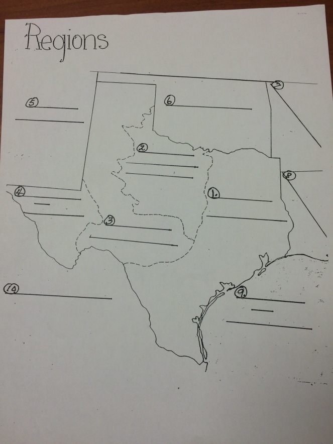
I often put this map either in a center or have everyone color it on a Friday while I catch up on writing conferences or small group. This map also becomes a study guide for a later test.
My friend, Margie Gray, came up with a great idea for this test. She uploaded a photo of the map into Google Draw. Then, she created blocks with the answer choices. This enabled students to drag and drop the answers on the map. I was just blown away by this suggestion and will use it next year. This is a great accommodation for students with writing difficulties, but is also a more hands on way for all students to learn. If your school is short on technology, you would also just print out the study guide and cut apart the answers at the top. Students could move the pieces around that way as well.
Writing Connection: We are usually learning about capitalization (common and proper nouns) about this time. We talk about why the regions are capitalized.
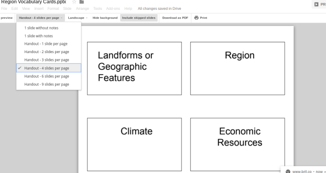
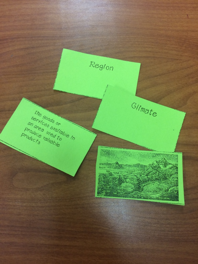
Before I teach the regions of Texas, I spend a lesson working on the vocabulary.
To prepare for the lesson, I print off the attached slides on small cards. In order to print them in Google Slides, go to File-Print Settings and Preview–Then choose the number of slides per page to print.
To keep the cards from getting mixed up, I print each set off in a different color of card stock. I am not a big fan of laminating. I have used these cards for six years without any problems.
You can click on my web link in the materials list below and just print one page per card if you prefer. If you would like me to share a copy in Google Slides, just send me an email to history1836@gmail.com
Here is the lesson. You can easily do this in fifteen minutes. You might use the slideshow to review the vocabulary before your region lesson each day for a minute.
TEKS
use social studies terminology correctly. [4.21A]
Objective: We can learn the vocabulary necessary to learn the regions of Texas.
Proof: We can prove we met our objective by working with partners in a card game.
You can also have students to a hands on activity to understand clearly what an elevation map is and how they are made using this great lesson from National Geographic. I have done this lesson by just making a paper cone and cutting it apart as well (which I actually like better than the clay and string).
Since I’m much shorter on time these days, I do the lesson below. I usually do it the second week of school….towards the end of the week of possible. Writing workshop is just beginning to get into full-swing, and I am already noticing those who need extra help getting started. This lesson does take a bit more time, but I use the time while the students color their maps to pull some of those students up one at a time to get them going. A small amount of investment here is worth gold later on when these students aren’t so far behind.
This lesson takes about 15-20 minutes for a whole group lesson. Coloring the map takes about the same. I tell students they can go back to writing workshop when they finish coloring.
TEKS:
interpret geographic data, population distribution, and natural resources into a variety of formats such as graphs and maps [4.20B]
Objective: We can understand how topographic maps illustrate elevation.
Proof: We can prove we met our objective by creating an elevation map of Texas.
I spend a little bit of time discussing these land forms. I don’t spend a lot of time on the other land forms since they are not currently specific Texas TEKS in the fourth grade.
Students complete the topographic map of Texas together. I do the Mountains and Basins region together as a class since those are the most difficult to understand using the key. I keep a couple of finished maps every year to place around the room if students get confused. I also make extra copies for when they want to start over.
Here is a finished map you can show if you don’t have time to color one.